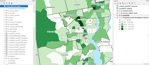
Frank Donnelly (Head of Library GIS and Data Services) and his team of student workers at GeoData@SciLi recently released the Ocean State Spatial Database (OSSDB), a geodatabase for conducting basic geographic analysis and thematic mapping within the State of Rhode Island. This open source database is intended to serve as a foundation for contemporary mapping projects, and as an educational tool for supporting GIS coursework and introducing spatial databases and SQL. The database is packaged in two different formats which can be used in desktop GIS software, such as QGIS and ArcGIS Pro.
The database contains geographic data compiled from the US Census Bureau and several other public sources. It includes census boundaries for towns and cities, census tracts, and zip codes, census data tables that can be used for mapping demographic and socio-economic characteristics, and reference layers for roads, railroads, and bodies of water. As part of the project, the team also created a series of scripts and a workflow for producing geospatial data for Rhode Island schools, colleges and universities, public libraries, and hospitals, so that RIGIS (the state’s official GIS repository), would have updated versions of these layers on an on-going basis.
The database, documentation, metadata, and code used for generating a subset of the tables and features are available for download from the Library’s GitHub page.
GeoData@SciLi is the Brown University Library’s geospatial data hub, and is a component of the Center for Library Exploration and Research (CLEAR). The database project exemplifies a number of goals of the CLEAR program, including: promoting teaching and research with data, publishing open resources that can be freely used by communities throughout the state, partnering with members of local government to create new data, and providing experiences for Brown students to engage in creative and scholarly research in the library.