
|
|
The
Robert S. and Margaret A. Ames Collection of Illustrated Books
Exploration and the Advent of Photography
Federally sponsored expeditions to the West resumed after the Civil War. Between 1867 and 1879, when the U. S. Geological Survey was established, four major expeditions set out to complete the task of surveying the topography, geology and natural resources of the west and it was their combined accomplishment that made possible large-scale Western settlement. The four "Great Surveys," as they are called, consisted of the King and Wheeler Surveys under the administration of the War Department and the Hayden and Powell expeditions under the auspices of the Department of the Interior. As the "Great Surveys" differed from their pre-Civil War antecedents in their greater inclusion of civilian specialists, particularly scientists, so too did the publications they produced--both in content and in appearance--and the greatest change was the impact of photography.
Despite their importance to the opening of the West and the scientific contributions
they made, one essential difference set the publications they produced apart
from those that went before---the advent of photography. While earlier forms
of illustration continued to be used, photography increasingly was the dominant
medium and it is for this reason that the Ames Collection does not focus on
the "Great Surveys." Even so, the collection includes the Wheeler
Report which includes earlier forms of illustration and the Dutton Atlas
of the Grand Canyon which accompanied the Powell report and is considered
to be one of the greatest examples of American chromolithography.
| REPORT
OF THE GEOLOGICAL EXPLORATION, VOL. II ARNOLD HAGUE AND S. F. EMMONS DESCRIPTIVE GEOLOGY The 1870s was a transitional period in book illustration as evidenced by contrasting the King and Wheeler Reports As stated in this volume of the King Report, "The plates are reproductions of photographs taken by T. H. O'Sullivan, photographer of this exploration, which have been accurately copied, lithographed, and printed by Julius Bien of New York." The lithographs have a different appearance from earlier lithographs because they are based upon photographs rather than drawings. Still, they have the traditional look of illustrations based upon mechanical rather than photographic processes. The O'Sullivan heliotypes in the Wheeler Report (two cases to the right) clearly point to the future while the King Report's lithographs hark to the past. This lithograph, based upon an O'Sullivan photograph, includes telegraph lines, another clear sign of technological change. |
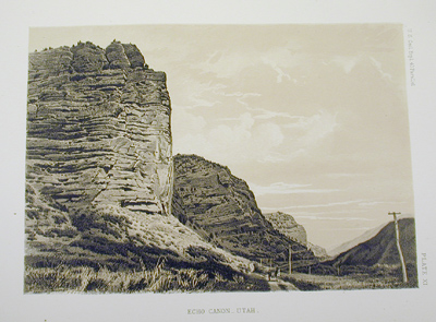 Echo Canyon, Utah |
CLARENCE KING REPORT OF THE GEOLOGICAL EXPLORATION OF THE
FORTIETH PARALLEL.....
WASHINGTON: GOVERNMENT PRINTING OFFICE, 1870-1880 VOL. I: SYSTEMATIC GEOLOGY, BY CLARENCE KING (1878) VOL. II: DESCRIPTIVE GEOLOGY, BY ARNOLD HAGUE AND S. F. EMMONS (1877) VOL. III: MINING INDUSTRY, BY JAMES D. HAGUE AND CLARENCE KING (1870) VOL. IV: PALAEONTOLOGY, BY F. B. MEEK, JAMES HALL AND R. P. WHITFIELD (1877) VOL. V: BOTANY, BY SERENO WATSON ET AL. (1871) VOL. VI: MICROSCOPIAL PETROGRAPHY, BY FERDINAND ZIRKEL (1876) VOL. VII: ODONTORNITHES....TOOTHED BIRD OF NORTH AMERICA, BY OTHNIEL C. MARSH (1880) Photography by Timothy O'Sullivan; drawings by H. W. Elliott, H. M. Martin, J. H. Emmerton and F. Barger; engraving and lithography by Julius Bien and E. Crisand Gift of the Office of the Chief of Engineers |
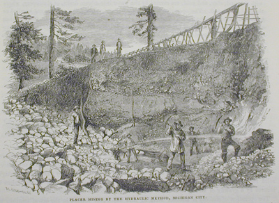 Placer Mining by the Hydraulic Method, Michigan City |
The seven volumes of the King expedition Report, which documented the exploration of a 100 mile wide strip along the 40th parallel from eastern Colorado to California, set the standard for the other three "Great Surveys," as the four came to be known. King's scope, if not his narrative and organizational skills, were adopted by the reports of the Hayden, Wheeler and, to some extent, Powell expeditions, which were to follow shortly thereafter. With their overlapping jurisdictions and resulting rivalry, the "Great Surveys" were discontinued by Congress in 1879 with the establishment of a single agency, the United States Geological Survey. King, an able administrator, was the first Director of the U.S.G.S., which continues to function today.
A Yale graduate, King staffed his expeditionary force with highly trained
civilian specialists, most of them young and many of whom subsequently became
leading experts in their fields (including William Whitman Bailey, a Brown alumnus
and later Professor of Botany at Brown). The individual contributions of these
men introduced to the U.S. the new science of micro-petrology, provided valuable
data for the mining industry that remained relevant well into the 20th century,
and made notable advances in paleontology, zoology, botany and topography.
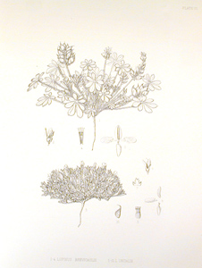 Lupinus Brevicaulis and Lupinus Uncialis |
REPORT OF THE GEOLOGICAL EXPLORATION, VOL. V SERENO WATSON, ET AL. BOTANY Ames Collection The use of traditional engraving and lithography continued to be used in the "Great Surveys" especially for the exacting reproductions of scientific specimens brought back to Washington from the various expeditions. Responding to changes in technology, the firm of Julius Bein produced both the traditional and the photographically-based plates. |
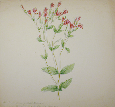
| 1867 DIARY AND DRAWINGS OF WILLIAM WHITMAN
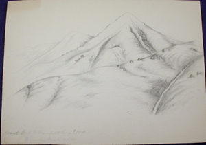
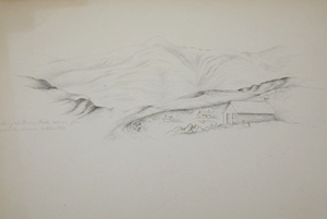
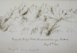
BAILEY Brown University Archives One of the major innovations of the King expedition centered upon the fact that it was essentially a civilian effort, though with government funding. Among the civilian specialists chosen was William Whitman Bailey, Brown class of 1864 and Professor of Botany from 1877 to 1906, who was recommended for the expedition post in botany by family friend Asa Gray. Although ill health forced Bailey to leave the expedition in under a year, his unpublished diary and drawings provide fresh insight into the King expedition. The diary and drawings shown here depict scenes of, and specimens taken in, Nevada. |
 |
 |
 |
 |
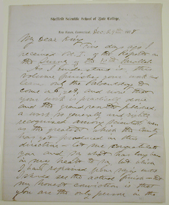 |
ALS FROM WILLIAM
H. BREWER TO CLARENCE KING, DEC. 24, 1878 John Hay Papers Gift of the Hay Family |
GEORGE M. WHEELER
REPORT OF THE UNITED STATES GEOGRAPHICAL SURVEYS WEST OF THE 100TH MERIDIAN
WASHINGTON: GOVERNMENT PRINTING OFFICE, 1875-1889
VOL. I: GEOGRAPHICAL REPORT BY GEORGE M. WHEELER, 1889
VOL.II: ASTRONOMY BY JOHN H. CLARK, F. KAMPF ET AL., 1877
VOL. III: GEOLOGY BY J.J. STEPHENSON AND C.A. WHITE, 1875
VOL. 1V: PALEONTOLOGY--BY CHARLES WHITE AND E. D. COPE, 1877
VOL. V: ZOOLOGY BY H.C. YARROW ET AL., 1875
VOL. VI: BOTANY BY J.T. ROTHROCK ET AL., 1878
VOL. VII: ARCHAEOLOGY BY FREDERICK W. PUTNAM ET AL., 1879
Photography by Timothy O'Sullivan; drawings by George D. Clarke, H.M. Martin,
C.K. Worthen, J.C. McConnell, R. J. Morgan, Robert Ridgway, W.H. Seaman et al.;
maps by Weyss and Thompson and Weyss and Lang; lithography by Sinclair and Son,
Julius Bien, The Graphic Co.; heliotypes by The Heliotype Printing Co.
Ames Collection
Because of their reliance upon photography, the Ames Collection does not focus
on the "Great Surveys," a notable exception being the Wheeler Report, included
because of the high quality of its illustrations and the fact that it encompasses
virtually all illustration techniques of the day--from woodcuts and wood and
steel engravings, to lithography, chromolithogray, to the photographic process
of heliotype.
| REPORT OF THE.....SURVEYS WEST OF THE
100TH MERIDIAN VOL. VII FREDERICK PUTNAM ET AL. ARCHAEOLOGY Ames Collection |
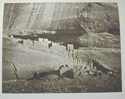 Ruins in the Canyon de Chelly, New Mexico |
Wheeler's idea was accepted and he was put in charge of an expedition whose
initial objective was the topographic mapping of all those vast and little known
areas that remained unexplored to the west of the 100th meridian, an area comprising
deserts, mountains, high plateaux and increasingly hostile Indians. Gradually
the scope of the expedition expanded to include, like the other "Great Surveys,"
geology, zoology, ethnology, etc. The field work lasted from 1871 to 1879, when
the newly established U. S. Geological Survey took over its work. Despite the
officers and enlisted men in his expedition, Wheeler also employed a significant
number of civilians, including Timothy O'Sullivan, who was borrowed from the
King survey. It was on the Wheeler expedition that O'Sullivan made some of his
most famous photographs, those of Canyon de Chelly.
|
REPORT OF THE SURVEYS.....WEST OF THE
100TH MERIDIAN, VOL. V ZOOLOGY The Wheeler Report was truly a melding of old and new illustration technologies. Heliotypes gave an immediacy to the field reports that the most beautiful lithograph could not impart while the precision of engraving and lithography remained important for documenting specimens such as these butterflies. |
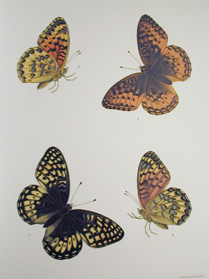 Argynnis Nokomis |
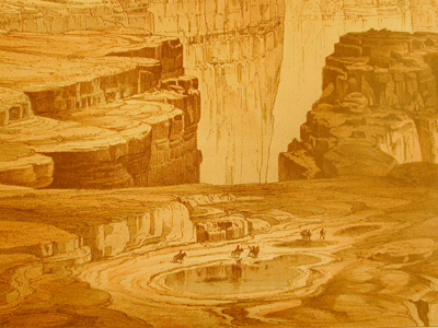
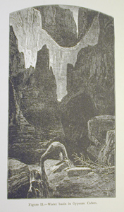 Water basin in Gypsum Canyon |
J. W. POWELL EXPLORATION OF THE COLORADO RIVER OF THE WEST AND ITS TRIBUTARIES, EXPLORED IN 1869, 1870, 1871, AND 1872
Gift of Frederick S. Peck In the late 1860s. Powell, a Midwesterner, was serving as Lecturer and Curator of the Museum at Illinois Normal University. While holding this position he organized groups of students and amateur naturalists which crossed the plains to the Colorado mountains, General Grant providing troops for protection against Indians. These excursions led to funding from the Smithsonian, and in 1869 Powell made his first official exploration of the West, the expeditions continuing into the next decade. In 1875, Powell was appointed director of the second division of the Survey of the Rocky Mountain Region, a position he retained until all surveys were subsumed under the U. S. Geological Survey in 1879. When Clarence King resigned as Director of the U.S.G.S., Powell succeeded him and remained Director until 1894.
|
| J. W. POWELL CANYONS OF THE COLORADO MEADVILLE, PA.: FLOOD & VINCENT, 1895 Gift of the Children of William Torrey Harris
|
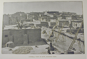 General view of Zuni, looking west. |
The 1875 Exploration is illustrated with wood engravings exclusively, taken from both photographs and drawings, again perhaps a sign of a tight budget. However, the drawings were by Thomas Moran, whose engravings and vast painted canvases produced upon his return from the West popularized the Grand Canyon and created indelible images of the history and myth of the American West.
Shown here are the 1875 official Exploration with a
wood engraving after Moran and the 1895 Canyons of the Colorado
with a photograph of a Zuni pueblo.
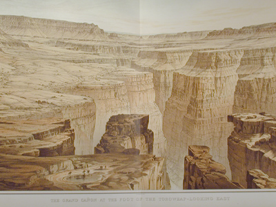 The Grand Canyon at the foot of the Toroweap, looking west. |
CLARENCE E. DUTTON ATLAS TO ACCOMPANY THE MONOGRAPH ON THE TERTIARY HISTORY OF THE GRAND CANON DISTRICT WASHINGTON: DEPT. OF THE INTERIOR, UNITED STATES GEOLOGICAL SURVEY, 1882 Drawings by William H. Holmes and Thomas Moran; maps by J. H. Renshawe, George M. Wheeler, Sumner Bodfish; lithography by Julius Bien Ames Collection |
Even greater than Dutton's contribution, from an esthetic
standpoint, is the great Atlas that accompanied the
Tertiary History. The art work of Thomas Moran and
especially that of William H. Homes, who provided the greater number of illustrations,
led to the creation of one of the greatest of all government publications and
a triumph of chomolithographic technique.
 Grand Canyon |
Holmes was a self-taught ethnologist and
anthropologist who rose to the top of his profession as director of the
Bureau of American Ethnology, a participant in pioneering expeditions
to the Mayan ruins of Mexico, and the first Director of the Field Museum
in Chicago. Despite these accomplishments, Holmes' first love was art,
which he studied seriously as a young man, and his talent led to his inclusion
as a panoramic artist on the "Great Survey" expedition of F.V. Hayden
to Yellowstone. In the course of his work, Holmes became a competent geologist,
a fact that distinguishes his illustrations in the later Tertiary
History Atlas; while Moran's panoramas were perhaps more painterly,
Holmes' were more accurate. As noted in Ron Tyler's Prints of the West, the late date (1882) for the use of such elaborate chromolithogaphy is due to the fact that no camera was yet capable of depicting both the sweep of the panorama and the detail that an artist/geologist of Holmes' skill could capture. Other authorities concur with Tyler, Wallace Stegner stating that Holmes' illustrations of the Grand Canyon were "the highest point to which geological or topographical illustration ever reached in this country." |
| Early Days | Great Leap Westward | Expansion Resumed | Methods of Printing & Illustration | About the Collection |
Last Updated: Tuesday, 10-Mar-2015 13:55:24 EDT.
© 2000, Brown University Library. All rights reserved.
There have been [an error occurred while processing this directive]
accesses of this page since November2, 2000