
|
|
The
Robert S. and Margaret A. Ames Collection of Illustrated Books
The Great Leap Westward:
Federally-sponsored Exploration from the 1840s to the Civil War
Click on an image to view a larger version or a detail.
| CHARLES WILKES NARRATIVE OF THE UNITED STATES EXPLORING EXPEDITION DURING THE YEARS 1838, 1839, 1840, 1841, 1842 Philadelphia: Lea and Blanchard, 1845. Drawings by Alfred T. Agate,
Joseph Drayton, Titian Ramsay Peale, Charles Wilkes et al.; drawings
"on wood" by F. O. C. Darley, J. H. Manning and W. G. Armstrong; steel
and wood engravings by W. E. Tucker, Jordan & Halpin, R. S. Gilbert,
J. H. Brightly, R. H. Pease, B. F. Childs, J. J. Butler, Rawdon, Wright
and Hatch et al.; maps engraved by Sherman and Smith, Edward Yeager,
and William Smith. |
 Kilauea Volcano in Hawaii |
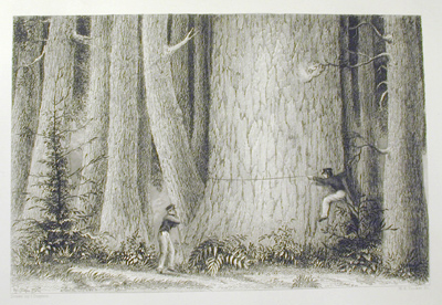 Expedition members measuring a giant redwood in Oregon |
By 1842, Congressional interest in the Wilkes expedition had waned considerably and only one hundred copies of the Narrative were authorized. Wilkes thereupon acquired publication rights for the Narrative and between 1845 and 1858 some nine editions appeared. A production tour de force for its day, the Narrative contains the work of eleven artists and over 40 individually named engravers. Probably the first of the western expedition accounts to become a best-seller, the Wilkes Narrative offered both an exciting story and inspiring illustrations to a young nation just beginning to imagine itself as a potential major power. The illustrations in the Wilkes Narrative were the first American-produced depictions of the northwest. |
| J. C. FREMONT REPORT OF THE EXPLORING EXPEDITION TO THE ROCKY MOUNTAINS IN THE YEAR 1842 AND TO OREGON AND NORTH CALIFORNIA IN THE YEARS 1843-'44. (U. S. Senate, 28th Cong., 2nd sess. Exec. Doc. 174) Washington: Gales & Seaton, 1845. Drawings and maps by Charles Preuss; lithography by E. Weber & Co. Rare Book Collection |
As described by Ron Tyler in Prints of the West, Fremont, of the Corps of Topographical Engineers, "personified Western exploration. Teaming up with Kit Carson and others, he mapped the famous Oregon Trail and penetrated the towering Rocky Mountains....symbolizing America's 'Manifest Destiny' as possessor of the West. His second expedition was a virtual circumnavigation of the region, and the third, made just as the Mexican War began, involved him in the conquest of California." The John Hay Library owns accounts of all of Fremont's exploits, the volume on display being the report of the first and second expeditions which the government authorized to be published together in 1845. This is the earliest book in this online exhibition to include lithography. |
The purpose of the 1842 Report was, as Fremont later wrote in his memoirs, to open what became quickly known as the Oregon Trail. The 1843/44 expedition, undertaken at the instigation of Senator Thomas Hart Benton of Missouri, Fremont's father-in-law, resulted in the recognition of the fact that the Great Basin, which Fremont named, drained eastward rather than toward the west coast as previously assumed. And it was Fremont's rhapsodic description of the Salt Lake Valley that served as inspiration to Brigham Young to move his persecuted Morman band from Nauvoo, Illinois to Utah.
William Preuss, a German native, was primarily a cartographer
rather than an artist and the journal record that he left of his three expeditions
with Fremont are notable for his disdain both for Fremont and for the scenery
he depicted, which he compared most unfavorably to that of the Alps.
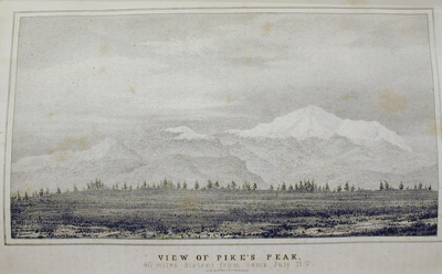 View of Pike's Peak |
Although far more modest in size and scope than
the Narrative of the Wilkes expedition, Fremont's
Report was also much less expensive and its
popularity was such that it went through some 25 editions in the U. S.
and England, making Fremont a hero in the process. As "The Pathfinder"
he would later serve as Senator from California and, in 1856, he would
run unsuccessfully for President as the first candidate to be nominated
by the Republican Party.
|
| W.H. EMORY NOTES OF A MILITARY RECONNOISSANCE, FROM FORT LEAVENWORTH, IN MISSOURI, TO SAN DIEGO, IN CALIFORNIA, INCLUDING PART OF THE ARKANSAS, DEL NORTE, AND GILA RIVERS. (U.S. Senate, 30th Cong., 1st, sess. Ex. Doc. 7). Washington: Wendell and Van Benthuysen 1848. Drawings by John Mix Stanley; map by Joseph Welch, lithography by E. Weber & Co. Ames Collection |  Ruins of the Casa Grande |
![]()
![]()
![]()
JOHN RUSSELL BARTLETT
 Tucson, Sonora (Arizona). This plate shows Bartlett at work with his sketchpad. |
JOHN RUSSELL BARTLETT PERSONAL NARRATIVE OF EXPLORATIONS AND INCIDENTS IN TEXAS, NEW MEXICO, CALIFORNIA, SONORA, AND CHIHUAHUA, CONNECTED WITH THE UNITED STATES AND MEXICAN BOUNDARY COMMISSION, DURING THE YEARS 1850, '51, '52 AND '53. New York: D. Appleton and Company, 1854. Drawings by Bartlett [augmented by Seth and Harrison Eastman et al; lithography by Sarony & Co; woodcuts by various hands.
Ames Collection |
The Mexican War and its aftermath witnessed an upsurge of exploration sponsored by the federal government. Two of the most important individuals to be involved in documenting the area seized from Mexico were John Russell Bartlett and William H. Emory, both of whose works are contained within the Ames Collection.
Bartlett's Personal Narrative grew out of the Treaty of Guadalupe Hidalgo of 1848 which concluded the Mexican War. A joint U.S.-Mexican commission was authorized to survey the international boundary eastward from a designated point on the Pacific coast to the Rio Grande and from a point in the Gulf of Mexico up the Rio Grande itself. The survey was delayed due to political in-fighting in Washington, insufficient funds and a lack of equipment. Dissension continued once commission deliberations began, with Bartlett agreeing with Mexico's contention that the boundary should be further north than had been established by the U.S. survey; taking such a stand, though probably correct by the terms of the treaty, led to Bartlett's dismissal. The ultimate disposition of the boundary dispute would not be resolved until the Gadsden Purchase of 1854, whereby the U.S. paid Mexico $15 million in exchange for a survey line that established the present-day boundary.
The federal government refused to publish Bartlett's account of his work as Boundary Commissioner, but a leading commercial publisher, D. Appleton and Company, brought out the Personal Narrative in 1854, while tensions over the boundary dispute still ran high. Without official sponsorship the Personal Narrative probably was deprived of expensive full color plates but it was, and still is, admired for Bartlett's elegant prose and the high quality of its lithographs, based upon Barlett's sketches and augmented by professional artists Seth and Harrison Eastman, among others.
John Russell Bartlett is a familiar name in Rhode Island. Born in Providence, he became a successful banker, political figure and bookseller It was interest in American history and his friendship with Whig politicians that led to his appointment as Boundary Commissioner in 1850. After his dismissal, he returned to Providence where he was elected Secretary of State in 1855, a post he retained for 17 years. During this period, Bartlett organized the official records of the state and compiled the ten-volume Records of the Colony of Rhode Island, 1636-1792.
For much of the last thirty years of his life, Bartlett devoted his energies to writing books on Rhode Island history and assisting John Carter Brown in building the latter's collection of Americana, the latter activity culminating in the publication of his John Carter Brown Catalogue.
| WILLIAM H. EMORY et al.
REPORT ON THE UNITED STATES AND MEXICAN BOUNDARY SURVEY, MADE UNDER THE DIRECTION OF THE SECRETARY OF THE INTERIOR Vol. I--(U.S. House of Representatives, 34th Cong., 1st sess., Ex. Doc. 135). Washington: Cornelius Wendell, Printer, 1857. Vol II--(U.S. Senate, 34th Cong., 1st sess., Ex. Doc. 108). Washington: A.O.P. Nicholson, Printer, 1859. Drawings by Arthur C. V. Schott, John E. Weyss, A. de Vaudricourt; engravings by William H. Dougal and James D. Smillie; lithograpy by Sarony, Major, & Knapp and Bowen and Co.; maps by Jekyll and Hall. Ames Collection Emory was, like Bartlett, a member of the U.S. Boundary Survey team following the Mexican War, his role being that of surveyor and chief astronomer. With Bartlett's dismissal, Emory, whose survey of the southwest had been published a decade earlier, completed the work and wrote the official report. The altered boundary created through the Gadsden Purchase is included in the Emory account.
|
 Vol. I: Lipan Warrior |
 Vol. II: Momotus Coeruleiceps |
Thanks
to government support, the Emory report is lavishly illustrated with excellent
maps by Jekyll and Hall and numerous, woodcuts, steel and copperplate
engravings, and both colored and tinted lithographs. Volume I, of which 10,000 copies were printed, consisted of Emory's personal account of the expedition, along with that of Lt. N. Michler and two scientific studies, one on geology and paleontology by James Hall et. al, and the second of fossils by T. A. Conrad. Volume II, of which only 1,000 copies were printed, is devoted to the botany and zoology of the region, with studies by John Torrey on general botany, George Engelmann on cacti, S. F. Baird on mammals, birds and reptiles, and Charles Girard on fish. The 25 colored plates, lithographed by Bowen & Co., are particularly impressive. |
| [JOHN M. LETTS] A PICTORIAL VIEW OF CALIFORNIA; INCLUDING A DESCRIPTION OF THE PANAMA AND NICARAGUA ROUTES, WITH INFORMATION AND ADVICE INTERESTING TO ALL, PARTICULARLY THOSE WHO INTEND TO VISIT THE GOLDEN REGION. BY A RETURNED CALIFORNIAN. New York: Henry Bill, 1853. Sold by Subscription Only. Frontis. from a sketch by G. W. Casilear; drawings by George V. Cooper; "on stone" by J. Cameron; lithography by G.W. Lewis and Brown & Severin. Ames Collection |
 Cooper sketching at left; Letts interviewing near wheel. |
Letts' account of the California gold rush is one of the most vivid depictions of the rigors of travel to California by the isthmian route and life in both frontier boomtowns like San Francisco and rugged mining camps such as Sutter's Fort. George V. Cooper, a lithographer, painter, cameo cutter and sculptor, traveled with Letts between 1849 and 1852, drawing all the plates for A Pictorial View. The plate shown here depicts Letts conducting an interview in an apparent gold mining camp while Cooper himself sketches in the background.
Letts' Pictorial View is the exception to the collecting principle of the Ames Collection which focuses on major, official expeditions rather than on private travel narratives. However, the Letts adds an important new title that complements the John Hay Library's Eberstadt Collection of Western Travel Narratives, bequeathed by alumnus Charles Eberstadt, the leading bookseller of western Americana of his day.
 Head of Ke-Uh-Ah-Que-Ho-No, the Main Branch of the Red River |
RANDOLPH B. MARCY and GEORGE
B. McCLELLAN EXPLORATION OF THE RED RIVER OF LOUISIANA, IN THE YEAR 1852. (U.S. Senate, 32nd Cong., 2nd sess. Ex. Doc. 54) Washington: Robert Armstrong, 1853. Drawings by Marcy and McLellan; engravings by W. H. Dougal and J. H. Richard; lithography by James Ackerman; maps by Marcy. Ames Collection The Red River, much of which today marks the
boundary between Texas and Oklahoma, passed through the southern areas
of the Louisiana Purchase. Due to the inhospitable terrain through which
its more westward reaches flowed, the Red had remained largely unexplored,
its source and headwaters unknown. The Marcy expedition of 1852 was
intended to rectify this situation and, although much useful data was
accumulated and documented through the resulting report, Marcy misattributed
the source of the river to the spring depicted in the adjoining plate.
Not until the Ruffner-McCauley expedition of 1876 was the true source
of the Red discovered. Landscape, topographic and figure drawing were all requirements at West Point and it was therefore not unusual for expedition leaders who had attended West Point, as both Marcy and McLellan had done, to produce the maps and illustrations that accompanied their reports. The fact that no artist is noted on the Marcy report implies that Marcy himself and/or McLellan (the controversial Civil War general and Marcy's future son-in-law) produced the report's illustrations.
|
| HOWARD STANSBURY AN EXPEDITION TO THE VALLEY OF THE GREAT SALT LAKE OF UTAH: INCLUDING A DESCRIPTION OF ITS GEOGRAPHY, NATURAL HISTORY, AND MINERALS, AND AN ANALYSIS OF ITS WATERS: WITH AN AUTHENTIC ACCOUNT OF THE MORMON SETTLEMENT. Philadelphia: Lippincott, Grambo & Co., 1852. Drawings by F. C. Grist and John Hudson; lithography by Ackerman. Ames Collection |
 Cave on Fremont's Island |
In 1849, Col. John J. Abert, commander of Topographical
Engineers, assigned Capt. Howard Stansbury to survey the area around the Great
Salt Lake. The intent of the expedition was to determine a more satisfactory
wagon route from Fort Bridger, Wyoming to Salt Lake City and also to explore
possible routes for a transcontinental railway. Impeding Stansbury's progress
were cholera outbreaks, the desertion of soldiers lured away by the California
gold rush, and suspicion on the part of Mormon settlers who feared that Stansbury
was a spy. Stansbury persevered however, and became the first surveyor to completely
circle the Great Salt Lake. The Stansbury report, with its many handsome lithographs,
proved so popular that Lippincott reprinted it twice; it also was translated
into German. The Stansbury report is a particularly good exemplar of tinted
lithography, as seen in these two plates, one using a uniform pink tint and
the other using both pink and blue with a touch of hand-applied red watercolor.
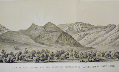 View of Part of the Western Slope of Promontory Range Great Salt Lake |
As was typically the case with accounts of government
explorations of the time, the narrative text of the Stansbury expedition
was followed by several focused appendices by a variety of individual
experts. These appendices ranged from zoology and botany to paleontology
and meteorological data and were based on samples and notes brought back
by the expedition. In some cases, the author provided the drawings from
which Ackerman produced lithographs, as did Spencer F. Baird and Charles
Girard in the zoological appendix and John Torrey for several of the plates
in the botanical appendix. Some drawings were signed by other artists
commissioned for the job and many others are by unknown hands.
|
| LORENZO SITGREAVES REPORT OF AN EXPEDITION DOWN THE ZUNI AND COLORADO RIVERS. (U.S. Senate, 33rd. Cong., 1st sess. Exec. Doc. unnumbered) Washington: Beverley Tucker, 1854. Drawings by R. H. Kern; lithography by Ackerman. Ames Collection The Sitgreaves expedition traversed the area west of Albuquerque and as far south as San Diego, exploring a hitherto little known desert area and providing details of the flora and fauna of the region. Richard Kern, the expedition artist, was particularly interested in Indian ethnology and made careful depictions of the customs, ceremonies and daily life of the native Americans encountered on the expedition.
|
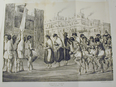 Buffalo Dance - Pueblo de Zuni |
 Big Cañon at the Mouth of the Diamond River |
JOSEPH C. IVES REPORT UPON THE COLORADO RIVER OF THE WEST, EXPLORED IN 1857 AND 1858. (U. S. Senate., 36th Cong., 1st sess., Exec. Doc. unnumbered) Washington: Government Printing Office, 1861. Drawings and sketches by H. B. Mollhausen, F. W. Egloffstein, J. J. Young, J. C. Ives; lithography by Sarony, Major & Knapp; maps by F. W. Egloffstein. Ames Collection
|
| REPORTS OF EXPLORATIONS AND SURVEYS,
TO ASCERTAIN THE MOST PRACTICABLE AND ECONOMIC ROUTE FOR A RAILROAD FROM
THE MISSISSIPPI RIVER TO THE PACIFIC OCEAN Vol. I-X-- (U.S. Senate, 33rd Cong. 2nd Sess. Exec Doc. 78) Washington: Beverley Tucker, 1855-1859 Vol. XI: (U.S. Senate. 36th Cong., 2nd sess., Exec. Doc. unnumbered) Washington: George W. Bowman, 1861 Vol. XII (U.S. Senate, 33rd. Cong., 1st sess., Exec. Doc. unnumbered) Washington: Thomas H. Ford, 1860. Drawings by John Mix Stanley, Richard H. Kern, J. J. Young, Charles Koppel, F.W. Egloffstein, Gustavus Sohon, Heinrich Mollhausen, John Cassin, J. H. Richard, Charles Girard et al.; engravings by Selmar Siebert, R. Hinshelwood, R. Metzeroth, F. Artos et al; woodcuts by Nathaniel Orr, J. W. Orr, W. Roberts, Lossing and Barritt, Whitney and Jocelyn, Richardson and Cox et al. maps by William P. Blake, Gouverneur K. Warren et al; lithography by Sarony, Major and Knapp, James Ackerman, A. Hoen, Julius Bien, P.S. Duval, John T. Bowen, Thomas Sinclair, Hoffman and Knickerbocker. Ames Collection |
Although several of the government-sponsored
expeditions of the 1840s and 50s had the exploration of possible trans-continental
railroad routes as one of their goals, it was not until the expeditions
that produced the massive, multi-volume Reports of
Explorations and Surveys, to Ascertain the....Route for a Railroad From
the Mississippi River to the Pacific Ocean that systematic data
for such a project was collected. Rival routes were promoted by sectional political interests, individually powerful Congressmen, and various economic forces whose interests would be affected by the route chosen. With no single route able to overcome the resulting stalemate, Congress authorized four (ultimately five) surveys to determine the most practical route. Each survey leader naturally promoted the virtues of his own survey and, coupled with continuing Congressional deadlock followed by the Civil War, the railroad project languished, not to be completed until 1869. The route ultimately chosen ran along the 38th parallel from Kansas City to the Pacific as surveyed by John W. Gunnison and, following his death at the hands of the Ute Indians, by Edward G. Beckwith. |
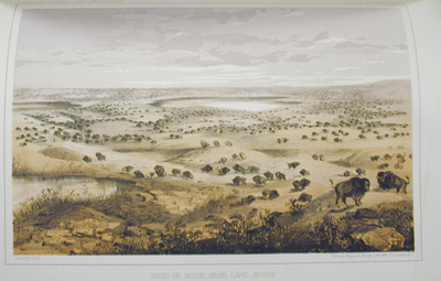 Vol. XII: Herd of Bison, Near Lake Jessie |
Such a major undertaking involved the
efforts of over 100 trained scientists who collected geological, cartographic,
zoological and botanical data, as well as over a dozen field artists (one
of whom, the talented Richard H. Kern, also lost his life on the Gunnison
expedition) and many engravers and lithographers based in Washington,
New York, Baltimore, Philadelphia and Albany, New York. |
In all, over 700 paintings and drawings were produced.
Ron Tyler, in his Prints of the West, estimates that
the surveys cost some $455,000 while the publication costs totaled $1,200,000,
not an excessive figure when it is realized that the Pacific
Surveys resulted in 295,000 individually bound volumes and 19,560,000
illustrative plates!
Inasmuch as the purpose of the field drawings was to depict topography suitable
to railroad building, beauty and drama were of little or no consequence. As
Lt. Beckwith stated, "The Landscape views are presented with no purpose of presenting
the beauties of the scenery of the country....little attention has been paid
to the beautiful execution of foregrounds." Even so, the artists brought to
their work a keen eye for the dramatic and often filtered the images they produced
with the Romantic sensibility current in 19th century art. Distortions or misrepresentations
sometimes resulted, as in the case of Mollhausen's Indian drawings; more frequently,
such alterations occurred at the hands of the engravers or lithographers who
sometimes "improved" original images for artistic effect or for political or
scientific reasons. Overall however, the plates included in the
Railroad Surveys , and accounts of other western expeditions as well,
served both as reliable documents and as inspiration to a lay audience for whom
the West was exotic and dangerous but also a place where their future might
lie.
| RAILROAD SURVEY, VOL. V ROBERT S. WILLIAMSON REPORT OF EXPLORATIONS IN CALIFORNIA FOR RAILROAD ROUTES..... Drawing by Charles Koppel Ames Collection |
 Los Angeles |
 Indian Altar and Ruins of Old Zuni. Lithography by Thomas Sinclair |
RAILROAD SURVEYS, VOL. III A. W. WHIPPLE REPORTS OF EXPLORATIONS AND SURVEYS.... Drawing by Heinrich Balduin Mollhausen Ames Collection Whipple was displeased with Mollhausen's depictions of Indians, whom Whipple admired and who, Whipple felt, were not shown in a complimentary fashion. Note the two white men in this plate casting what appear to be suspicious glances at the Indian performing a religious rite. |
| RAILROAD SURVEY, VOL. X A. L. HEERMAN REPORT UPON BIRDS COLLECTED ON THE SURVEY Drawing by John Cassin, with John T. Bowen, lithographer Ames Collection Cassin, a Philadelphia ornithologist, was paid $5,320 to draw, print and hand color 2,000 copies each of 38 plates of birds brought back from the Railroad Surveys; the total was 76,000 plates at a cost of 7 cents each. Ron Tyler, in his Prints of the West, states that the "bird pictures produced under Cassin's oversight might not be as aesthetically pleasing as John James Audubon's, but neither are they as anthropomorphic or romantic." Lithographer J. T. Bowen died during the production of the Railroad Surveys and Cassin married his widow, assuming the presidency of the Bowen company. The ornithological studies produced from the Railroad Surveys were of such outstanding quality that they were republished in 1860 under the aegis of the Smithsonian Institution. Entitled The Birds of North America, the illustrations and text by Spencer Baird are still considered to be among the best of the early ornithological works on American birds. A copy of The Birds of North America is in the John Hay's Lownes Collection of Significant Books in the History of Science. |
 PYRANGA HEPATICA Observed in the San Francisco Mountains of New Mexico. |
 |
RAILROAD SURVEY, VOL. VI J. S. NEWBERRY REPORT UPON THE ZOOLOGY Drawing by J. H. Richard, engraving by R. Metzeroth MEPHITIS BICOLOR (Little Striped Skunk) Ames Collection |
As to capturing specimens, the advice was as follows: "The best way is to catch the animal in a box trap, and to plunge the trap unopened into water, by that means drowning the skunk. If killed suddenly very dead by a rifle ball or shot, they are inodorous. Another mode sometimes practiced, and sometimes successful, is to attack the skunk with a small dog, and while his attention is engaged, to walk boldly up, and seizing him by the tail, raise him instantly into the air, when he may be despatched by blows on the head, his system of defence in such circumstances being inoperative."
| Early Days | Great Leap Westward | Expansion Resumed | Methods of Printing & Illustration | About the Collection |
Last Updated: Tuesday, 10-Mar-2015 13:52:45 EDT.
© 2000, Brown University Library. All rights reserved.
There have been [an error occurred while processing this directive]
accesses of this page since November 2, 2000